• About
    • ABOUT US
    • LHRCA Transition
    • GSCA Office Move
    • Strategic Plan
    • Conservation Authorities Act Requirements
    • Governance
    • Contact Staff
      • Full Staff Directory
      • General Contact
      • Planning/Permit Inquiries
      • What’s New?
    • Donate
    • Fees
    • Mapping (GIS)
      • Grey Sauble Conservation Authority Regulations Mapping
      • Property Permitted Uses Map
      • Request GIS & LiDAR Data
      • Mapping Application Terms of Use
    • Publications & Downloads
    • Board Login
    • Employment Opportunities
    • Volunteer Opportunities
    • Grey Sauble Conservation Foundation
      • About
  • Explore Conservation Areas
    • Parking
    • Visiting Conservation Areas (Important Info and Closures)
    • Permitted Uses Map
    • Top Conservation Area Pages
      • Inglis Falls CA
        • Inglis Falls Arboretum Accessibility Project
        • Inglis Falls Accessibility Enhancements
        • Inglis Falls Management Plan
        • Inglis Falls Arboretum Alliance (IFAA) & Nursery
      • Eugenia Falls CA
        • Cenotaph Naturalization Project
        • Eugenia Falls Conservation Area Management Plan Information Page
      • Bruce’s Caves CA
      • Spirit Rock CA
        • Spirit Rock Conservation Area Management Plan
      • Hibou CA
        • Hibou Management Plan
        • Hibou Conservation Area Playground Project
      • Bognor Marsh CA
      • Indian Falls CA
      • Pottawatomi/Jones Falls CA
      • Old Baldy CA
      • Arran Lake Conservation Area (CA)
      • Epping-John Muir Lookout
    • View Explore Guide
    • Find Properties Using A Map
    • Pavilion Rentals
    • Climbing Waiver
    • Give Back to Nature
  • Water Management
    • Water Management
    • Flood Forecasting & Warning
      • Flood Notices
      • Types of Flood Notices
      • Low Water Response
    • Watershed Conditions Maps
    • Flood and Erosion Control Infrastructure
    • Water Quality Monitoring
      • Benthic Monitoring
      • Surface Water Quality Monitoring
      • Groundwater Monitoring
    • Watershed Report Cards
    • Drinking Water Source Protection
  • Planning & Regulations
    • Contact Our Planning Department
    • Introduction
    • Plan Input & Review and Regulations
    • Submitting Permit Applications
    • Regulations Mapping
    • Tile Drainage Permitting Guide
    • Home Flood Protection
  • Environmental Education & Events
    • Grey Sauble Day Camps
    • Environmental Education
      • Nature Discovery Lending Program
      • Resilient Wetlands Program
      • Environmental Book Club
      • Specialist High Skills Major
      • Turtle Stewardship Program
        • Turtle Fundraiser Mugs
      • Watershed Guardians
      • World of Trees
    • Environmental Education Sponsorship & Donations
    • Earth Film Festival
    • Forest Festival
    • Salmon Discovery Day
    • Water Festival
    • Environmental Education Framework
  • Forestry & Landowner Services
    • Stewardship
      • Stewardship Grants
      • Landowner Champions
    • Forestry Services
    • CA Forest Management
      • Plantation Management
      • Hardwood Forest Management
    • Forest Management Tenders
    • Invasive Species
  • Feedback & Requests
    • Freedom of Information Requests
    • Accessibility Requests & Feedback
    • Report A Violation On Grey Sauble-Owned Properties
    • Report a Violation Related to Development Permits
    • Request GIS Data
    • Client Satisfaction Survey

PROTECT. RESPECT. CONNECT. 519 376 3076

237897 Inglis Falls Road, Owen Sound
explore@greysauble.on.ca
Grey Sauble Conservation AuthorityGrey Sauble Conservation Authority
  • About
    • ABOUT US
    • LHRCA Transition
    • GSCA Office Move
    • Strategic Plan
    • Conservation Authorities Act Requirements
    • Governance
    • Contact Staff
      • Full Staff Directory
      • General Contact
      • Planning/Permit Inquiries
      • What’s New?
    • Donate
    • Fees
    • Mapping (GIS)
      • Grey Sauble Conservation Authority Regulations Mapping
      • Property Permitted Uses Map
      • Request GIS & LiDAR Data
      • Mapping Application Terms of Use
    • Publications & Downloads
    • Board Login
    • Employment Opportunities
    • Volunteer Opportunities
    • Grey Sauble Conservation Foundation
      • About
  • Explore Conservation Areas
    • Parking
    • Visiting Conservation Areas (Important Info and Closures)
    • Permitted Uses Map
    • Top Conservation Area Pages
      • Inglis Falls CA
        • Inglis Falls Arboretum Accessibility Project
        • Inglis Falls Accessibility Enhancements
        • Inglis Falls Management Plan
        • Inglis Falls Arboretum Alliance (IFAA) & Nursery
      • Eugenia Falls CA
        • Cenotaph Naturalization Project
        • Eugenia Falls Conservation Area Management Plan Information Page
      • Bruce’s Caves CA
      • Spirit Rock CA
        • Spirit Rock Conservation Area Management Plan
      • Hibou CA
        • Hibou Management Plan
        • Hibou Conservation Area Playground Project
      • Bognor Marsh CA
      • Indian Falls CA
      • Pottawatomi/Jones Falls CA
      • Old Baldy CA
      • Arran Lake Conservation Area (CA)
      • Epping-John Muir Lookout
    • View Explore Guide
    • Find Properties Using A Map
    • Pavilion Rentals
    • Climbing Waiver
    • Give Back to Nature
  • Water Management
    • Water Management
    • Flood Forecasting & Warning
      • Flood Notices
      • Types of Flood Notices
      • Low Water Response
    • Watershed Conditions Maps
    • Flood and Erosion Control Infrastructure
    • Water Quality Monitoring
      • Benthic Monitoring
      • Surface Water Quality Monitoring
      • Groundwater Monitoring
    • Watershed Report Cards
    • Drinking Water Source Protection
  • Planning & Regulations
    • Contact Our Planning Department
    • Introduction
    • Plan Input & Review and Regulations
    • Submitting Permit Applications
    • Regulations Mapping
    • Tile Drainage Permitting Guide
    • Home Flood Protection
  • Environmental Education & Events
    • Grey Sauble Day Camps
    • Environmental Education
      • Nature Discovery Lending Program
      • Resilient Wetlands Program
      • Environmental Book Club
      • Specialist High Skills Major
      • Turtle Stewardship Program
        • Turtle Fundraiser Mugs
      • Watershed Guardians
      • World of Trees
    • Environmental Education Sponsorship & Donations
    • Earth Film Festival
    • Forest Festival
    • Salmon Discovery Day
    • Water Festival
    • Environmental Education Framework
  • Forestry & Landowner Services
    • Stewardship
      • Stewardship Grants
      • Landowner Champions
    • Forestry Services
    • CA Forest Management
      • Plantation Management
      • Hardwood Forest Management
    • Forest Management Tenders
    • Invasive Species
  • Feedback & Requests
    • Freedom of Information Requests
    • Accessibility Requests & Feedback
    • Report A Violation On Grey Sauble-Owned Properties
    • Report a Violation Related to Development Permits
    • Request GIS Data
    • Client Satisfaction Survey

For more information about visiting conservation areas and updates on closures, please click here.

Grey Sauble Conservation owns and manages 11,734 hectares (28,995 acres) of land throughout its 3,191 square kilometre (1,983 square mile) jurisdiction.  Our properties have been divided into one of three classifications based upon the reasons for their purchase, conditions on title and our management objectives.  These classifications are:  Conservation Areas, Management Areas and Nature Preserves.
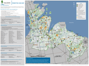
Click on the property point to navigate to the appropriate webpage:

***Access to the base of any GSCA waterfall and areas beyond the designated viewing locations at the top of the falls are strictly prohibited***

Please enjoy these beautiful waterfalls from the designated viewing areas only.

Drones are not permitted on any Grey Sauble Conservation Authority property.

  • View All 80 Properties here
  • Administration Centre & Arboretum
  • Arran Lake
  • Bognor Marsh Management Area
  • Bruce’s Caves Conservation Area
  • Epping-John Muir Lookout Conservation Area
  • Eugenia Falls Conservation Area
  • Feversham Gorge
  • Hepworth
  • Hibou Conservation Area
  • Indian Falls Conservation Area
  • Inglis Falls Conservation Area
  • Jones Falls & Pottawatomi Conservation Area
  • Massie Hills Management Area
  • Old Baldy Conservation Area
  • Spirit Rock & McNeill Estate Conservation Area
  • The Glen
  • Trout Hollow (Bighead River)

Click for Permitted Uses Map      Click for Explore Guide


Provide Feedback or Ask Questions

Send us an email and we'll get back to you, asap. Please send program specific inquiries directly to the appropriate staff member. Please check our staff contact list: https://www.greysauble.on.ca/about-us/staff-directory/

Follow us on Facebook

What’s New?

  • Forestry Tenders: Kolapore Uplands Management Area
  • MEDIA RELEASE (Sept. 28, 2026): Greenbelt Foundation Awards $30,000 to Grey Sauble Conservation Authority for Green Fields, Clean Streams Project
  • MEDIA RELEASE (Sept. 21, 2026): Grey Sauble Conservation Celebrates Volunteers and Unveils New Turtle Conservation Signage at Bognor Marsh Management Area
  • MEDIA RELEASE (July 2, 2026) Celebrating a Legacy: John Bittorf Retires After 40 Years with Grey Sauble Conservation

For Program Specific Inquiries:

Planning & Development Regulation Related Inquiries

Forestry & Tree Sale Related Inquiries

Grey Sauble Owned Properties & Trails Related Inquiries

Daycamp Related Inquiries

To see our full Staff Contact List Go Here 

For All Other Inquiries (DO NOT USE FOR PLANNING & PERMIT RELATED INQUIRIES)

Contact Info

  • Grey Sauble Conservation Authority
  • 237897 Inglis Falls Road, Owen Sound, N4K 5N6
  • 519-376-3076

Office Hours: Monday to Friday 9am – 4pm (closed during Board of Directors meetings, the afternoon of the 4th Wednesday of every month)

Accessibility Feedback & Requests

Latest News Releases

  • Forestry Tenders: Kolapore Uplands Management Area
  • MEDIA RELEASE (Sept. 28, 2026): Greenbelt Foundation Awards $30,000 to Grey Sauble Conservation Authority for Green Fields, Clean Streams Project
  • MEDIA RELEASE (Sept. 21, 2026): Grey Sauble Conservation Celebrates Volunteers and Unveils New Turtle Conservation Signage at Bognor Marsh Management Area
  • MEDIA RELEASE (July 2, 2026) Celebrating a Legacy: John Bittorf Retires After 40 Years with Grey Sauble Conservation

Governance

To find out about the GSCA Board of Directors, their meeting schedule, agendas, minutes and more, visit the Governance page.

Conservation Areas

© 2026 · Grey Sauble Conservation.

Press Enter to search · Esc to close