• About
    • ABOUT US
    • Governance
    • Contact Staff
      • Full Staff Directory
      • General Contact
      • What’s New?
    • Donate
    • Fees
    • Mapping (GIS)
      • Grey Sauble Conservation Authority Regulations Mapping
      • Property Permitted Uses Map
      • Request GIS & LiDAR Data
      • Mapping Application Terms of Use
    • Publications & Downloads
    • Board Login
    • Employment Opportunities
  • Explore Conservation Areas
    • Parking
    • Top Conservation Area Pages
      • Inglis Falls CA
        • Inglis Falls Management Plan
        • Inglis Falls Arboretum Alliance (IFAA) & Nursery
      • Eugenia Falls CA
        • Eugenia Falls Conservation Area Management Plan Information Page
      • Bruce’s Caves CA
      • Spirit Rock CA
        • Spirit Rock Conservation Area Management Plan
      • Hibou CA
        • Hibou Conservation Area Playground Project
      • Bognor Marsh CA
      • Indian Falls CA
      • Pottawatomi/Jones Falls CA
      • Old Baldy CA
      • Arran Lake Conservation Area (CA)
      • Epping-John Muir Lookout
    • Visiting Conservation Areas (Important Info/Closures)
    • View Explore Guide
    • Find Properties Using A Map
    • Pavilion Rentals
    • Climbing Waiver
  • Water Management
    • Introduction
    • Current Watershed Conditions
    • Flood Forecasting, Warning & Low Water Monitoring
      • Flood Notices
      • Types of Flood Notices
    • Drinking Water Risk Management
    • Dams & Flood Control
    • Water Quality & Benthic Monitoring
    • Watershed Monitoring / Data Collection
    • Watershed Report Cards & Health Reviews
      • Bothwell’s Creek Watershed Health Review
      • Indian Brook Watershed Health Review
      • Pottawatomi River Watershed Health
      • Sauble River Watershed Health
      • Watershed Report Card FAQ
    • Working In or Around Water?
    • Home Flood Protection
  • Permits & Planning
    • Planning and Permit Fee Update
    • Submitting Permit and Planning Applications
    • Navigating the Process
    • Planning & Regulations Introduction
    • Plan Input & Review and Regulations
    • Home Flood Protection
  • Learning & Engaging
    • Foundation
      • About
      • Foundation Board of Directors
      • Memorial Forests
      • Donations
      • Grey Sauble Foundation 500 Club
      • Bruce Calvert Earth Day Hike
      • Earth Film Festival
      • Malcolm Kirk Environmental Scholarship
    • Grey Sauble Day Camps
    • Environmental & Conservation Education
    • Outdoor Education
    • Water Festival
    • Forest Festival
    • Young Naturalists
    • Invasive Species
  • Forestry & Landowner Services
    • Stewardship
    • CA Forest Management
      • Forest Management Stakeholder Input
    • Forestry Services
    • Plantation Management
    • Forest Management Tenders
  • Feedback & Requests
    • Freedom of Information Requests
    • Accessibility Requests & Feedback
    • Report a Violation Related to Grey Sauble Owned Properties
    • Report a Violation Related to Development Permits
    • Request GIS Data

PROTECT. RESPECT. CONNECT

Find Us!
explore@greysauble.on.ca
Volunteer, Donate or Support Foundation Initiatives
Grey Sauble Conservation AuthorityGrey Sauble Conservation Authority
  • About
    • ABOUT US
    • Governance
    • Contact Staff
      • Full Staff Directory
      • General Contact
      • What’s New?
    • Donate
    • Fees
    • Mapping (GIS)
      • Grey Sauble Conservation Authority Regulations Mapping
      • Property Permitted Uses Map
      • Request GIS & LiDAR Data
      • Mapping Application Terms of Use
    • Publications & Downloads
    • Board Login
    • Employment Opportunities
  • Explore Conservation Areas
    • Parking
    • Top Conservation Area Pages
      • Inglis Falls CA
        • Inglis Falls Management Plan
        • Inglis Falls Arboretum Alliance (IFAA) & Nursery
      • Eugenia Falls CA
        • Eugenia Falls Conservation Area Management Plan Information Page
      • Bruce’s Caves CA
      • Spirit Rock CA
        • Spirit Rock Conservation Area Management Plan
      • Hibou CA
        • Hibou Conservation Area Playground Project
      • Bognor Marsh CA
      • Indian Falls CA
      • Pottawatomi/Jones Falls CA
      • Old Baldy CA
      • Arran Lake Conservation Area (CA)
      • Epping-John Muir Lookout
    • Visiting Conservation Areas (Important Info/Closures)
    • View Explore Guide
    • Find Properties Using A Map
    • Pavilion Rentals
    • Climbing Waiver
  • Water Management
    • Introduction
    • Current Watershed Conditions
    • Flood Forecasting, Warning & Low Water Monitoring
      • Flood Notices
      • Types of Flood Notices
    • Drinking Water Risk Management
    • Dams & Flood Control
    • Water Quality & Benthic Monitoring
    • Watershed Monitoring / Data Collection
    • Watershed Report Cards & Health Reviews
      • Bothwell’s Creek Watershed Health Review
      • Indian Brook Watershed Health Review
      • Pottawatomi River Watershed Health
      • Sauble River Watershed Health
      • Watershed Report Card FAQ
    • Working In or Around Water?
    • Home Flood Protection
  • Permits & Planning
    • Planning and Permit Fee Update
    • Submitting Permit and Planning Applications
    • Navigating the Process
    • Planning & Regulations Introduction
    • Plan Input & Review and Regulations
    • Home Flood Protection
  • Learning & Engaging
    • Foundation
      • About
      • Foundation Board of Directors
      • Memorial Forests
      • Donations
      • Grey Sauble Foundation 500 Club
      • Bruce Calvert Earth Day Hike
      • Earth Film Festival
      • Malcolm Kirk Environmental Scholarship
    • Grey Sauble Day Camps
    • Environmental & Conservation Education
    • Outdoor Education
    • Water Festival
    • Forest Festival
    • Young Naturalists
    • Invasive Species
  • Forestry & Landowner Services
    • Stewardship
    • CA Forest Management
      • Forest Management Stakeholder Input
    • Forestry Services
    • Plantation Management
    • Forest Management Tenders
  • Feedback & Requests
    • Freedom of Information Requests
    • Accessibility Requests & Feedback
    • Report a Violation Related to Grey Sauble Owned Properties
    • Report a Violation Related to Development Permits
    • Request GIS Data

Spirit Rock Conservation Area

92 HIGHWAY 6, WIARTON ON

Coordinates: Latitude: 44.7621° North, Longitude: -81.1419° West - UTM X Easting: 488766.9116, Y Northing: 4956533.418
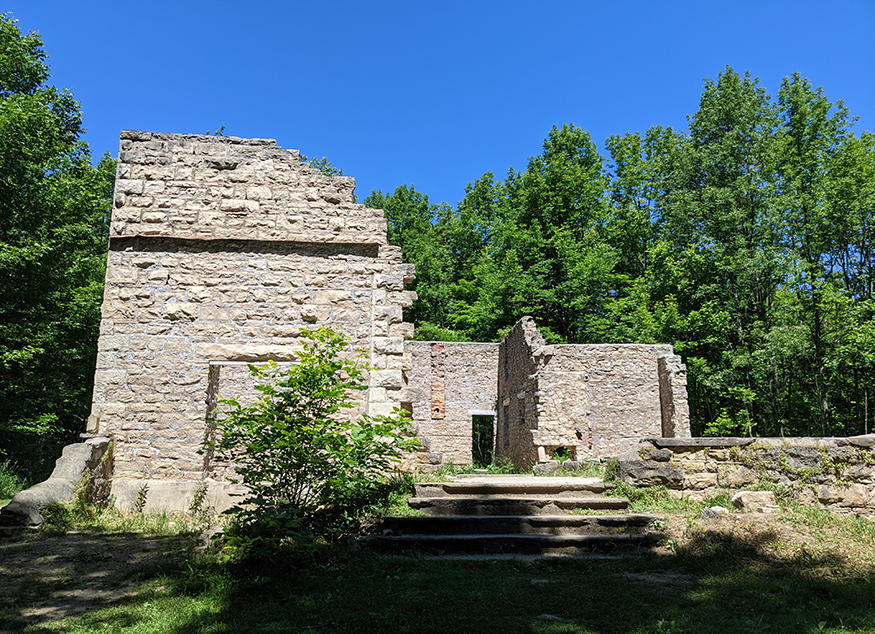
PROPERTY INFORMATION

Encompassing 87 hectares, the site features historical ruins, an impressive view from the top of the Niagara Escarpment, a spiral staircase to the water’s edge, and access to the Bruce Trail.


- A MUST SEE

- IMPRESSIVE VIEWS & UNIQUE SPIRAL STAIRCASE THAT TAKES YOU DOWN ESCARPMENT EDGE

- CLOSENESS TO ESCARPMENT USUALLY RESERVED FOR ROCK CLIMBERS

- OVER 5 KM HIKING TRAILS

- OPEN LATE SPRING TO FALL


PAID PARKING

SITE HISTORY

You can also visit the ruins of the McNeill Estate, which provides a glimpse into the history of Bruce County and its settlers.

In 1881, this site became home for Alexander McNeill who developed the land into beautiful garden, manicured lawns and productive orchards.

The heart of the estate was the Corran, a 17-room mansion lavished with oriental carvings, ancient weapons, tapestries and book-lined walls.

The Gaelic meaning for Corran is ‘point of land running into the sea’. McNeill’s mansion was modeled and named after his childhood home in Northern Ireland.
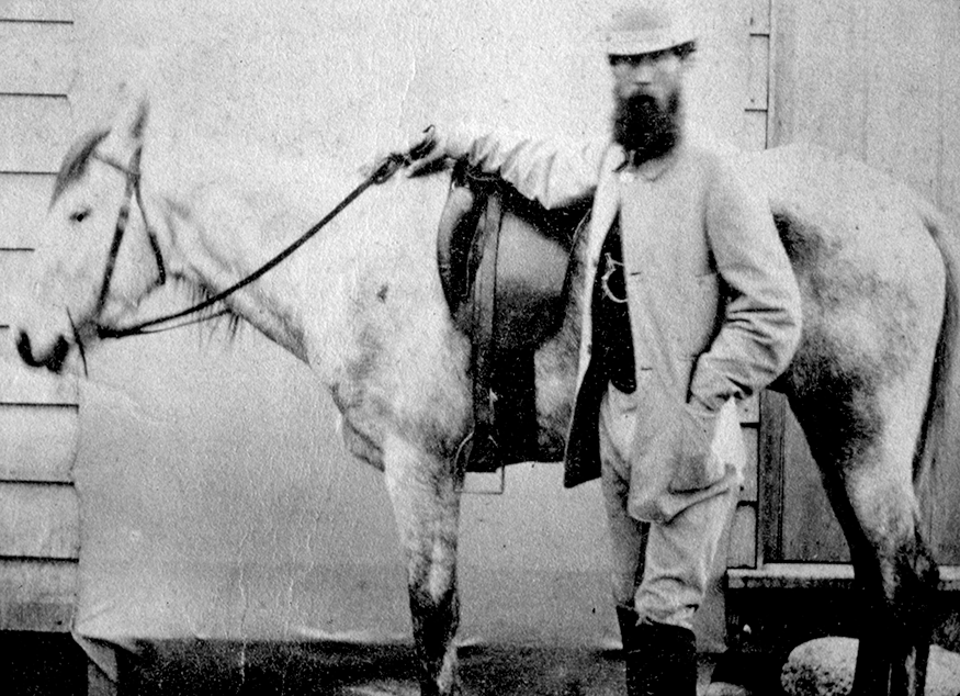
ALEXANDER McNEILL

Alexander McNeill was born in Northern Ireland and served as the Federal Member of parliament for the North Bruce Riding, 1881-1901.

He was a supporter of Britain and its empire and one of the ‘Noble 13’ who opposed Sir John A. Macdonald on a number of issues.

McNeill was a quiet man, fond of reading and a lover of flowers. He lived on the estate with his wife Hester and their son Malcolm. Hester died quite young, before the estate was completely finished.

Unfortunately, after McNeill died, Malcolm was more interested in parties than managing the estate, and the family fortune dwindled away. 

Following Malcolm’s death, the housekeeper, who had been willed the estate, sold it in 1960 to a Toronto resident. Without fulltime occupancy at the mansion, vandals victimized the site. The property was sold in 1976 to the Conservation Authority. Shortly after, a fire destroyed the mansion, leaving only a stone shell, which is still visible today.


What’s New?

  • Attention Woodlot Owners!
  • WATERSHED CONDITIONS STATEMENT
  • Bill 23, More Homes Built Faster Act, 2022
  • GSCA Issues Letter to Premier Ford and Ministers Re: Bill 23, the More Homes Built Faster Act

For Program Specific Inquiries:

Planning & Development Regulation Related Inquiries

Forestry & Tree Sale Related Inquiries

Grey Sauble Owned Properties & Trails Related Inquiries

Daycamp Related Inquiries

To see our full Staff Contact List Go Here 

For All Other Inquiries (DO NOT USE FOR PLANNING & PERMIT RELATED INQUIRIES)

Contact Info

  • Grey Sauble Conservation Authority
  • 237897 Inglis Falls Road, RR 4, Owen Sound, ON N4K 5N6
  • 519-376-3076

Accessibility Feedback & Requests

Latest News Releases

  • Attention Woodlot Owners!
  • WATERSHED CONDITIONS STATEMENT
  • Bill 23, More Homes Built Faster Act, 2022
  • GSCA Issues Letter to Premier Ford and Ministers Re: Bill 23, the More Homes Built Faster Act

Governance

To find out about the GSCA Board of Directors, their meeting schedule, agendas, minutes and more, visit the Governance page.

Conservation Areas

© 2023 · Grey Sauble Conservation.

  • Membership
  • Donate
  • Memorial Forest Tree
  • 500 Club
  • Mailing List
Prev Next

Type and press Enter to search


IMPORTANT INFORMATION

Staff are working in a combination or in-office and remote situations. Please utilize email as the most reliable way to reach our staff. A full staff directory is available on our website.

Download our new PROPERTY EXPLORE GUIDE!

Property Closures:

  • – Indian Falls Conservation Area is closed due to flooding on the trails.
  • – Eugenia Falls Conservation Area

Please read Visiting Conservation Areas for important info.

***PLANNING AND PERMITS SERVICE INTERRUPTION ADVISORY***
Please note that we are currently operating at a temporarily reduced capacity while also experiencing a high number of applications and inquiries to our Environmental Planning Department at this time. Please use our contact form only for inquiries related to planning and development permits. Inquiries must include all requested information for a response by a planning staff member.

COVID-19 INFORMATION

Please utilize email or website contact forms (for planning and development permit related inquiries) as the most reliable way to reach our staff at this time.

Visit this link for more information about visiting properties during COVID-19.  Please visit this link for ongoing updates related to COVID-19.

Ok Cancel
Font Resize
Contrast Mode
Accessibility by WAH
  • 2-5 Years After Harvest/Thinning
  • 2019 Day Camp Survey
  • 5-10 Years After Harvest/Thinning
  • About Us
    • ABOUT US
    • Board of Directors
    • Contact Staff Directly – 519 376-3076
    • Employment Opportunities
    • Publications
    • What’s New?
  • After a Harvest/Thinning
  • Agricultural Land Lease Tenders
  • Before Harvest/Thinning
  • Benefits of Plantation Management
  • CA Act Changes Bill 229
  • CA Forest Management
  • Categories
  • Children’s Programs
    • Community Relations
    • Environmental and Conservation Education Program Locations & Providers in Grey and Bruce Counties
    • Forest Festival
    • Grey Sauble Day Camp
    • Outdoor Education
    • Water Festival
    • Wildwater Program
    • Young Naturalists
  • Climbing Waiver
  • Conservation Areas by Activity
  • Conservation Areas By Map
  • Contact Us
  • COVID-19 Related Information
  • Eugenia Falls Conservation Area Management Plan Information Page
  • Fees for all Departments
  • First Harvest/Thinning
  • Forest Management Stakeholder Input
  • Forest Management Tenders
  • Forestry Services
  • Foundation
    • About
    • Bruce Calvert Earth Day Hike
    • Donations
    • Foundation Board of Directors
    • Malcolm Kirk Environmental Scholarship
    • Memorial Forests
    • Salmon Celebration – Guided Tours
    • Trees for Schools
  • Freedom of Information Requests
  • Grey Sauble Foundation 500 Club
  • Hibou Conservation Area Playground Project
  • Inglis Falls Arboretum Alliance (IFAA) & Nursery
  • INGLIS FALLS MANAGEMENT PLAN
  • Inglis Falls Management Plan Information Page
  • Invasive Species
  • Invasive Species
  • Lifecycle of a Plantation
  • Locations
  • Lymantria dispar dispar (LDD)
  • Mapping (GIS)
    • Grey Sauble Conservation Authority Regulations Mapping
    • Mapping Application Terms of Use
  • Memorial Forest Ceremony RSVP 1
  • Memorial Forest RSVP 2
  • Mixed Forest
  • My Bookings
  • Parking
  • Pavilion Rentals
  • Photo Contest
  • Planning & Regulations
    • Plan Input & Review and Regulations
    • Planning & Regulations Introduction
  • PLANNING AND PERMITTING FEE CONSULTATION
  • Plantation Management
  • Provide Feedback and Ask Questions
  • Risk Management Services
  • Second Harvest/Thinning
  • Spirit Rock Conservation Area Management Plan
  • Stewardship
  • Stewardship Grants
  • Story of a Harvest
  • Submitting Permit and Planning Applications
  • Subscribe to Updates About Inglis Falls Management Plan
  • Subscribe to Updates About the Eugenia Falls Management Plan
  • Subsequent Harvests/Thinnings
  • The Plantation is Established
  • Visiting Conservation Areas (Important Info/Closures)
  • Water Management
    • Current Watershed Conditions
    • Dams & Flood Control
    • Flood Forecasting, Warning & Low Water Monitoring
      • Flood Notices
      • Types of Flood Notices
    • Introduction
    • Water Quality & Benthic Monitoring
    • Watershed Monitoring / Data Collection
    • Watershed Report Cards
      • Watershed Report Card FAQ
    • Working In or Around Water?
  • Welcome
  • Welcome – OLD
  • What is a Plantation?